Showing posts with label Map. Show all posts

Sunday, December 6, 2009

New Oblique Satellite Images of Ramon's Crater, HaMakhtesh Hagadol, and HaMakhtesh HaKatan

Links of interest:

Safed Earthquakes

Bing oblique satellite images of Mitzpe Ramon

Bing oblique satellite images of Israel's most prominent geological features

Microsoft's Bing has come out with some new oblique satellite images of the Negev that surpass anything I have seen before. An oblique image is taken at an angle so as to enhance the contrast of topological features. Some of the new features shown are HaMakhtesh Hagadol (The Large Crater) and HaMakhtesh HaKatan (The Small Crater), each considerably smaller than Makhtesh Ramon, on whose rim Mitzpe Ramon sits. At the time of its charting Makhtesh Ramon was unknown, hence the name "The Large Crater" for Makhtesh Ramon's smaller brother. These are three of five such erosion craters in Israel, with only seven existing in the entire world. The Large and Small Crater are seen to the north east of Mitzpe Ramon and Ramon's Crater, the Small Crater lying near Highway 25, just west of the southern Dead Sea., and the Large Crater lying near Yeroham. They are easily seen in this high relief, oblique satellite image.


Makhtesh Ramon (Center, Orange marker); HaMakhtesh Hagadol and HamAkhtesh Hakatan (North East); Wadi al Jayb (Jordan Rift Valley)

Another wonderful geological feature, seen above, that is hard to see on maps is the Jordan Rift Valley, a continuation of the Great African Rift Valley that begins at Mt. Kilimanjaro in norther Tanzania, continues northward under the Gulf of Aqaba, through the Dead Sea and the Jordan River Valley, culminating in the Beqa'a Valley of Syria. This great trench, running nearly 5,000 miles, is formed by three tectonic plates that meet and pulll apart under the Gulf of Aqaba. This geologically active trench is responsible for generating Mt. Kilimanjaro itself as well as the earthquake of Jan. 1, 1837 which completely destroyed Safed.  The Jordan Rift Valley is marked on our map as "Wadi al Jayb", continuing up to and under the Dead Sea, and whose depth and extent is magnificently highlighted in the above oblique satellite image.

Geological features dominate the political geography of the Middle East. From the bottom: drying ponds of the Dead Sea, Dead Sea, Jordan River Valley, Sea of Galilee, Golan Heights (to the immediate right), Lebanon Mts. and Beqaa Valley veering off to the top right, all continuations of the 5,000 mile long Great African Rift Valley. Note also the prominent Negev border with Egypt which I cannot attribute to any geological feature.


Below, in this gorgeous satellite mosaic of a cloudless Africa and Middle East, we see the telltale markings of the Great African Rift Valley, running from Mt. Kilimanjaro (red marker), due north through Israel (blue marker), forming the Jordan Rift Valley, Dead Sea, Jordan River Valley, and the Beqa'a Valley in Syria.

While here take some time to enjoy the breath taking image of Lake Victoria, the Nile River and Delta (the verdant delta of the river being seen here quite literally). This is the first time I have ever seen evidence of the boundary between Israel and Egypt on a satellite image. If you look closely at the Negev's boundary with Egypt, you can see the triangular shape of the Negev's border clearly delineated on the map. I have no idea what causes this feature.
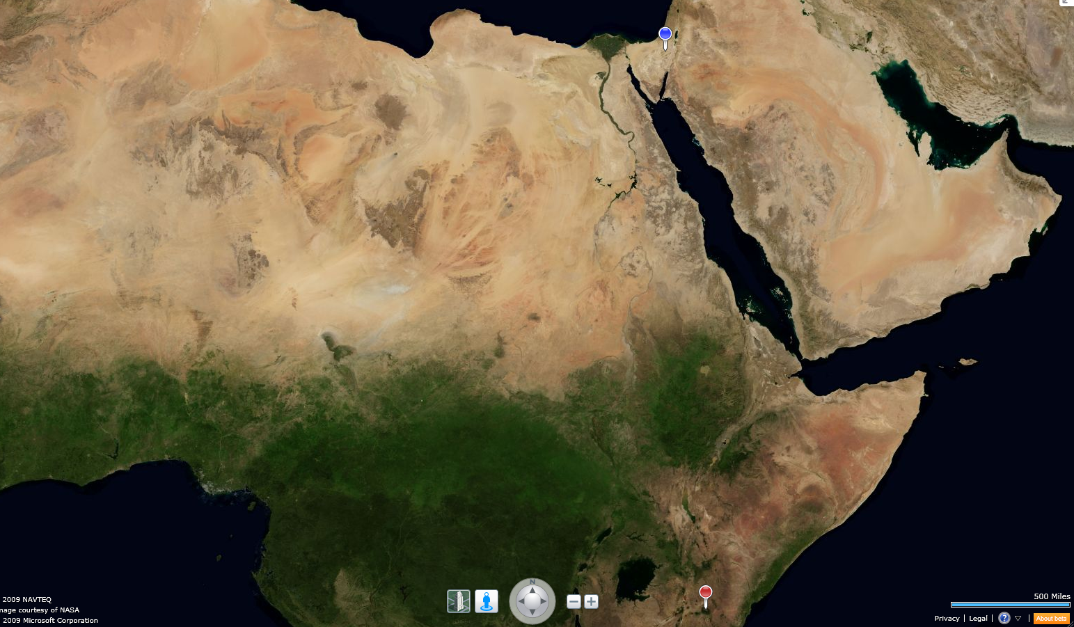

Great African Rift Valley, Lake Victoria, Nile River and Delta, Jordan Rift Valley, Dead Sea, & Jordan River Valley

Cloudless satellite images of such extent are difficult to prepare. They consist of thousands of tiled mosaic images of an area, each one taken when no clouds were present. This is the way the earth usually looks from space:

The cloudy third planet from the Sun

Large scale cloudless satellite mosaics were pioneered by Tom van Sant in the late '80s, and his satellite mosaic maps of a cloudless earth are some of the best known. I once had the privilege of interviewing Tom van Sant when he was a guest lecturer at the University of California, Berkeley, and I was the project manager for Project Sequoia 2000.


 Tom van Sant's original cloudless Earth, from thousands of satellite mosaic images


Thursday, November 19, 2009

Route 40 - The Road to Mitzpe Ramon

     
Useful links:
Google Map of Israel


Route 40 is the only road that leads into and out of Mitzpe Ramon. Except when it enters Ramon's Crater, it looks pretty much like this for its entire length: a well paved two lane highway wandering through a dun colored desert landscape of rolling hills and plateaus.


Route 40, heading north towards Be'er Sheva


Route 40 as it descends into Ramon's Crater

For some reason, I find desert driving to be completely exhausting. Perhaps it is the heat or the sun's glare, but a drive from Mitzpe Ramon to Be'er Sheva, approximately 1 hour, completely exhausts me and leaves me wrung out. I hope I am not getting old.

The View Along Route 40


One of the sights one sees along Route 40 is the occasional orchard. You will be driving along through a complete waste land, when all of a sudden, a patch of green appears on the horizon. It is an irrigated strip of land, usually bearing fruit trees or grape vines. Israel, of course, is a pioneer in techniques of desert irrigation, but what puzzles me the most is how even irrigated plants can gain a perch in the rocky desert soil. I will have to find out more about desert agriculture.

An Orchard Along Route 40

Also ubiquitous along Route 40 are the high tension power lines, which sing incessantly across the desert landscape.


Power Lines Along Route 40 with Desert Totem

Another common sight are the Bedouin shanty towns which line Route 40 for many miles from Be'er Sheva toward Mitzpe Ramon. They seem to grow in size and number every time I make the trip, and about which we will write more later.

Bedouin Shanty Town Along Route 40 Outside Be'er Sheva Toward Mitzpe Ramon

One also sees signs of agrarian and pastoral Bedouin life along Route 40. In the afternoon sun one can see a Bedouin shepard bringing his flock of sheep home across a dun colored hill, the close animals making the hill look like it has come alive with rippling life. On one trip to Be'er Sheva we saw these Bedouin boys on donkey-back tending their small herd of sheep.


Bedouin Boys Tending Flock Along Route 40

There is much to be seen in the desert, if you only have eyes for it.

Wednesday, November 18, 2009

Where is Mitzpe Ramon?

Many people draw a blank when we tell them we are moving to Mitzpe Ramon. It is a small and remote town in Israel's High Desert, so perhaps this is not surprising, unless you have visited it to explore Ramon's Crater or stopeed on your way to Eilat down Route 40. But Mitzpe Ramon is one of the easiest places to visualize: it sits right in the geographic center of the triangle of land that comprises Israel's Negev, the Desert.

"A" marks the spot:


Ramon's Crater itself occupies a remarkably large swath of the Negev with Mitzpe Ramon located at the center of the northern rim. There is only one road, Route 40, that cuts through the center of the crater, linking Eilat to the south with the rest of Israel.


Here is a larger topographic view that gives a better idea of the crater terrain and the wadis and nachlot that run through it.


Here is a topological view from an altitude of 23 miles. The airport indicated by the symbol was proposed but never built in Mitzpe Ramon; however, there are Israeli air force bases nearby.


Finally, this close-in topological street view gives some idea of the town's relationship to the crater, showing just how close the town lies to the crater rim. We live in the old section of town, hard by the crater's rim.


We are moving to Mitzpe Ramon, Israel

                       
Mitzpe Ramon (Ramon's Outlook)
Population: 5600
Lat: 30.612947464, Long: 34.8021125793
"A" marks the spot


We live in Englewood, NJ and are making Aliyah, moving to Mitzpe Ramon, Israel. To many people this just draws a blank reaction; they have no idea where Mitzpe Ramon is. Others react variously depending on their age. Older people tend to double-up in disbelieving laughter. (Joke: "I am going to Mitzpe Ramon." "Why, did you loose something?") Younger people, especially the younger married men we know say something like, "I'd go with you myself, except my wife would divorce me." These contrary responses reflect the dual nature of Mitzpe Ramon's past: at one time a "dumping ground" for Israel's "less desirable" immigrants, "nicht unsere" (not us) as they may have been called by Israel's founding elite of white, Ashkenazic, European Jews and its present as a growing desert, eco-tourist center.

So, what's the story with Mitzpe Ramon?

Mitzpe Ramon was built in 1950 as a temporary town for the workers building Route 40, connecting Beer Sheva with Eilat on the Red Sea. Even in 2009 it is physically remote, 50 miles south of Beer Sheva and 85 miles north of Eilat, with only a few large military bases nearby. A portion of the town's population today is comprised of military and civilian workers at the nearby military bases. It sits in the high desert of the Negev at 800 meters elevation (almost as high as Jerusalem at 900 meters). If you picture the triangle of land that composes Israel's southern Negev, Mitzpe Ramon sits at its geographic center. But the air is dry and a continual, freshening breeze blows there (sometimes quite stiffly), making even the hot desert afternoons bearable. In the winter this same wind makes it quite chilly.

Mitzpe Ramon's most distinguishing feature is that it sits at the rim of the largest geologically created crater in the world, Ramon's Crater (Machtesh Ramon, in Hebrew). The crater is about 650 feet deep from its rim at Mitzpe Ramon, and it extends some 25 miles in length and 5 miles in width. You could fit about 4 Manhattan Islands into its basin. (Craters can be created by impact [meteor-created] or volcanic action, or through geological erosion. Mitzpe Ramon's oblong, irregular shape reflects its creation by geological forces, rather than by impact or volcanic action, which tend to create circular craters.)

Ramon's Crater is the largest nature preserve in Israel, and Mitzpe Ramon is the visitor center for the nature preserve. There are two hotels and a large youth hostel in the town, and many Israelis start their tours or treks of the Crater in Mitzpe Ramon, or stop there to buy food and gas on their way to Eilat. There is a very upscale hotel currently under construction in Mitzpe Ramon, sitting right on the Crater's edge. (Autumn 2009)

Units of Fancy New Hotel Built on the Rim of Ramon's Crater

I have read that the opening of Route 90 down Israel's western border with Jordan has siphoned off alot of traffic from Route 40 to Eilat from the north of Israel, hurting tourism in Mitzpe Ramon, where tourists used to stop and visit the crater on their way to Eilat. But the rise of interest in eco-tourism and all things Green seems to be restoring the flow of tourists to Mitzpe Ramon. This is the source of the younger men's envy at our moving to Mitzpe -- if you are into hiking, biking, or running Ramon's Crater is one of the great places on Earth to do it, and Mitzpe Ramon is just a shout from the crater's edge.


Because of its location in the High Desert and its remoteness from urban centers, the air in Mitzpe Ramon is particularly clean and pure. It also enjoys some of the darkest skies anywhere in Israel. Thus, Israel's largest research astronomical observatory, the Wise Observatory, is located on a small plateau just 3 miles from the center of town. Unfortunately, growth and development of the town seems to be degrading dark sky conditions, and I do not believe the sodium vapor lights even have sky shields on them, quite surprising considering the proximity of the observatory. Nonetheless, Mitzpe Ramon is a prime location for star gazing and meteor watching, bringing out large crowds in the summer when the Perseids meteor shower reaches its peak in early August.

The Wise Observatory, on the Arad Ascent, 3 miles outside Mitzpe Ramon
Correction: These are actually the domes of the IAF radar facility just outside of Mitzpe Ramon. But they look alot like the domes of the Wise Observatory which lies high atop a mountain behind Mitzpe Ramon.

Although Mitzpe Ramon enjoys its new status as a growing eco-tourism destination, for much of its history it was a kind of "dumping ground" for some of Israel's "undesirable" Olim: First the dark-skinned Sephardic Olim from Morocco, later the Black Hebrews of Chicago, then the Russians. Much of the housing in the old part of town was government supported and poverty was high, due to the remoteness of the town. More recently the government has started selling off this government supported housing to its renters and investors. There is a market in the center of town, a Field School, about which I know little, and a B'nai Akiva Yeshiva moved to Mitzpe Ramon about 10 years ago from Dimona. There is also a Chabad that is building a new center. The Yeshiva has certainly changed the character of the town. There are about 150 families who belong to the Yeshiva community, and you see them and their children everywhere you go.

Whether observant or not, the town, I assume like many smaller towns in Israel, is quite traditional. As Shabbos starts, everything closes down, cars and buses stop running, stores close, and all becomes silent, with only the desert wind and the hum of air conditioners heard. It is really quite amazing.
Related Posts with Thumbnails