Showing posts with label Makhtesh Ramon. Show all posts

Thursday, February 18, 2010

An Oasis in the Desert

You see these as you drive along the highway. A lone tree standing far off or a cluster standing in a verdant patch of green. What could these be and how could they be in this barren waste? I often wondered this about the strange oases of green that I would see driving along Route 40. They were clearly not watered by springs bubbling from the ground. After the desert storms of this winter I started to understand.

An oasis of green in the barren waste of Machtesh Ramon

There are declivities in the desert landscape, some larger some smaller. Some are quite large, basically basins in the ground. During the dry season these topographic differences are hard to detect with the naked eye. When rain falls, however, these declivities gathter the waters unto themselves. Along the drainage paths of the waters, gullies and wadis form, giving way as they spread out to these shallow basins where waters gather. It is along these water trails and gatherings that plants and even trees begin to grow.

The photo above is of one of these basins in Machtesh Ramon. It is quite deep, since this is a mature tree growing near its center. As I observed these basins I also started to notice the work of man. There were berms that had been thrown up on the downhill side of the declivities' drainage, to hold even more water then they would naturally contain. When the water evaporates, the soil continues to hold moisture, giving rise to these mysterious patches of trees and grass, oases in a barren land.


The Storm of the Century - Aftermath III

Machtesh Ramon is drained by three rivers. The chief of these is Nachal Ramon that runs down the crater's center. All three are usually bone dry. After last month's rains all the rivers were freely flowing.
This dramatic shot shows Nachal Ramon with Mt. Ardon in the background.

Nachal Ramon flows with water. Mt. Ardon in the background.

Mt. Ardon is part of the crater's northeast wall, so it is actually a cliff, rather than a free-standing mountain. It is located at the point of the crater's heart-shaped septum.

"A" marks Mt. Ardon

 The mountain is well seen in the photo below, a distance of about 10 miles from this vantage point.

Mt. Ardon, center right, at the "point" of the prominent white cliffs
   

Wednesday, February 17, 2010

The Storm of the Century - II

The following day rain continued to pour down on Mitzpe Ramon and the central Negev. A rare collision of warm, moist air from Africa and cold air from Eastern Europe had created a storm that most had not seen in their lifetime. Over 6.5 inches of rain fell within 24 hours, more than had fallen in the past 10 years altogether.


I head to the Crater Overlook to experience the full force of the storm


Your intrepid reporter beats a hasty retreat from the fury of the storm


Thursday, January 7, 2010

F-16s Over Machtesh Ramon


Nothing can ruin a nice blue sky like spreading con trails. I remember once camping in Tuolumne Meadows in Yosemite National Park, one of the most pristine and stunning wilderness areas in America. High over head a jet plane flew, the roar of its engines surprisingly loud in the wilderness. All of a sudden, the con trail took a huge arc to the left, eventually returning to its straight line path. The pilot had stood the plane on its side so the passengers could get a look at Yosemite Valley, causing the flight path to veer off the straight and narrow. Soon the con trail spread and obscured the sky for some time.

There are no con trails that obscure the skies in Israel. First of all, Israel's friendly Arab neighbors to the east forbid the country's planes from flying in their air space, and pretty soon after that you're in Iraq and Iran air space, and who the heck wants to be there unless you plan to bomb a nuclear facility? Also, since Israel is so small, I imagine that most airlines scoot above or below its borders when flying east. So, the only planes one usually sees in Israeli skies are military.

There is a major air force base outside of Be'er Sheva and other air force bases not far from Mitzpe Ramon. Last Monday we saw Israeli F-16s on maneuvers over and through the crater. The planes would fly high circular loops around town, and then swoop down into the crater's mouth, eventually circling well behind the town into the high desert where continuous sonic booms would be heard in the distance. Eventually the booms became quite disconcerting. Occasionally a jet will break the sound barrier over the town, setting off all of the car alarms and causing quite a commotion.

It was quite a spectacle to stand on the observation deck over looking the crater and wait for the jets to appear. All of a sudden, out of nowhere they would come, one chasing the other, and no sooner there than gone. I captured their maneuvers in one pass shown below.


Israeli F-16 jets over Machtesh Ramon

Friday, January 1, 2010

Moonrise Over Machtesh Ramon - New Year's Eve 2010


Secular New Year's Eve 2010, Mitzpeh Ramon, is a quiet affair. As far as I can tell, there is nothing going on even at the hotels, but I shall check later. It is just after sunset, corresponding to the hebrew date of the 15th of Tevet, 5770 -- mid-month. A full moon rises gloriously over the machtesh (crater) marking the end of a long, low, violent, and greedy decade. Let us hope the opening of a new secular decade brings better things than the last.

Everywhere there seems to be a rising tide of anti-semitism in its new form - vilification and deligitimization of the State of Israel. And it's old form still alive, too, in the form of "jokes" like "Kick a Jew Day" or "Kill a Jew Day", most recently in a school in Australia. The Associated Press called the murderers of Rabbi Meir Avshalom Chai, the father of ten who was cut down in his prime by vicious terrorists in a drive-by shooting as he chauffeured his wife and children, "activists". It seems the world has learned nothing in the 90 years since W. B. Yeats wrote, "The best lack all conviction, while the worst are full of passionate intensity."

The Second Coming         

Turning and turning in the widening gyre
The falcon cannot hear the falconer;
Things fall apart; the centre cannot hold;
Mere anarchy is loosed upon the world,
The blood-dimmed tide is loosed, and everywhere
The ceremony of innocence is drowned;
The best lack all conviction, while the worst
Are full of passionate intensity.

Surely some revelation is at hand;
Surely the Second Coming is at hand.
The Second Coming! Hardly are those words out
When a vast image out of Spiritus Mundi
Troubles my sight; somewhere in sands of the desert
A shape with lion body and the head of a man,
A gaze blank and pitiless as the sun,
Is moving its slow thighs, while all about it
Reel shadows of indignant desert birds.
The darkness drops again; but now I know
That twenty centuries of stony sleep
Were vexed to nightmare by a rocking cradle,
And what rough beast, its hour come round at last,
Slouches towards Bethlehem to be born


But let it be known that we have learned, and Never Again means exactly what it says: NEVER AGAIN.


Moonrise over Machtesh Ramon, New Year's Eve 2010


Later this evening, a partial lunar eclipse was visible from here, reaching its peak around 9:30 PM local time. It is exactly astronomical mid-month, the start of a new secular year, the start of a new decade.


Partial lunar eclipse, Dec. 31, 2009; 9:30 PM local time, Mitzpe Ramon


The clouds that gather round the setting sun

Do take a sober colouring from an eye

That hath kept watch o'er man's mortality;

Another race hath been, and other palms are won.

Thanks to the human heart by which we live,

Thanks to its tenderness, its joys, and fears,

To me the meanest flower that blows can give

Thoughts that do often lie too deep for tears.

                                                                                     -- William Wordsworth

Wednesday, December 30, 2009

We are Visited by Mark and Uncle Rafi Finkel

I wish I could say we entertained the Finkels, but their visit coincided with the 10th of Tevet, a fast on the Jewish calendar, so the most we could do was show them around. Mark was in Israel for a friend's son's Bar Mitzvah. Mark is the kind of guy who will drop everything to attend a friend's simcha, and he was in Israel for just a short time for that. Uncle Rafi is one of the unsung heroes of the Jewish State. He came to Israel in 1948, after lying to get in to the Marines during WWII (he was under-age), "because of what happened to the Jews in Germany." He has been involved in many of the road building projects in Israel and can tell you just about everything that has happened here from personal experience.

Our first stop was at the little neighborhood shul at the crater's rim. It is divded into an Askenazic side and a Sephardic side. Since most of the residents of Mitzpe Ramon are Sephardim, it is by far the best attened in the neighborhood.

Uncle Rafi and Mark stand in front of our neighborhood shul in Mitzpe Ramon


The ark of the Sephardic shul is carved olive wood, and chandaliers hang in the traditional Sephardic style from a pyramidal roof.


 Mark in the Sephardic half of our neighborhood shul


The Askenazic side of the shul has an ark made of beaten copper, reminiscent of the copper cladding on the alter in the Temple reminding the people of Korach's sin of disputing the Kahunah. A giant, round metal chandalier hangs from the center of the pyramidal roof. When the rising sun shines through the eastern windows in the morning it were as if the glory of G-d filled the room.


A copper-clad ark graces the front of the Ashkenazic shul in Mitzpe Ramon

We next made our way to the eerie that overlooks Ramon's Crater, a spectacular 650 feet below.


The eerie overlooking Ramon's Crater, 650 feet below

We were fortunate to happen onto a herd of about 20 Ibex kids and mature Ibex by the crater rim. I believe this was a mixed herd of kids, females, and males, an oddity since the males and females usually group separately, except during breeding season in the fall.


Ibex kids grazing on seemingly nothing

Shortly after, a group of yeshiva students arrived to feed the kids bread.


 Yeshiva boys feed the young Ibex


Bochrim feed the kids (double-click to watch full-frame)


As we walked along we saw some magnificent young Ibex.


A magnificent young male Ibex at the rim of Machtesh Ramon

Public displays of art are common in Israel. Here a male Ibex looks like he is part of his own 2001 Space Odyssey:


2010: A Space Odyssey in Mitzpe Ramon - an Ibex discovers tools

This Ibex looks like he has been injured, perhaps by a predator. Ibex use their horns for protection, but also for mating fights. It is rare for an Ibex to be injured in a mating fight, although their horns are heavy and fierce.


A male Ibex displaying the scar of an old wound


Pam, Uncle Rafi, Mark, and Donny with Ibex and Space Odyssey Rocks of Mitzpe Ramon


Herd of young Ibex by the crater rim at Mitzpe Ramon

Of course, eventually the young boys do what all young boys do, chase the Ibex and stampede the herd off.


Yeshiva bochers stampede the herd of young Ibex

Eventually we come 'round to the Chabad House in Mitzpe Ramon. Here Mark and Uncle Rafi try to make some semblance of a "770" sign, sitting in front of the Chabad House.


Mark and Uncle Rafi make the sign of "770" in front of Mitzpe Ramon's Chabad House

Finally it was time to say good-bye. Mark and Uncle Rafi kindly gave us a ride to Be'er Sheva, where we picked up a rental car for the next of our round of activities. Thanks Mark and Uncle Rafi. L'hitraot!


See you again soon, Mark!


Sunday, December 6, 2009

New Oblique Satellite Images of Ramon's Crater, HaMakhtesh Hagadol, and HaMakhtesh HaKatan

Links of interest:

Safed Earthquakes

Bing oblique satellite images of Mitzpe Ramon

Bing oblique satellite images of Israel's most prominent geological features

Microsoft's Bing has come out with some new oblique satellite images of the Negev that surpass anything I have seen before. An oblique image is taken at an angle so as to enhance the contrast of topological features. Some of the new features shown are HaMakhtesh Hagadol (The Large Crater) and HaMakhtesh HaKatan (The Small Crater), each considerably smaller than Makhtesh Ramon, on whose rim Mitzpe Ramon sits. At the time of its charting Makhtesh Ramon was unknown, hence the name "The Large Crater" for Makhtesh Ramon's smaller brother. These are three of five such erosion craters in Israel, with only seven existing in the entire world. The Large and Small Crater are seen to the north east of Mitzpe Ramon and Ramon's Crater, the Small Crater lying near Highway 25, just west of the southern Dead Sea., and the Large Crater lying near Yeroham. They are easily seen in this high relief, oblique satellite image.


Makhtesh Ramon (Center, Orange marker); HaMakhtesh Hagadol and HamAkhtesh Hakatan (North East); Wadi al Jayb (Jordan Rift Valley)

Another wonderful geological feature, seen above, that is hard to see on maps is the Jordan Rift Valley, a continuation of the Great African Rift Valley that begins at Mt. Kilimanjaro in norther Tanzania, continues northward under the Gulf of Aqaba, through the Dead Sea and the Jordan River Valley, culminating in the Beqa'a Valley of Syria. This great trench, running nearly 5,000 miles, is formed by three tectonic plates that meet and pulll apart under the Gulf of Aqaba. This geologically active trench is responsible for generating Mt. Kilimanjaro itself as well as the earthquake of Jan. 1, 1837 which completely destroyed Safed.  The Jordan Rift Valley is marked on our map as "Wadi al Jayb", continuing up to and under the Dead Sea, and whose depth and extent is magnificently highlighted in the above oblique satellite image.

Geological features dominate the political geography of the Middle East. From the bottom: drying ponds of the Dead Sea, Dead Sea, Jordan River Valley, Sea of Galilee, Golan Heights (to the immediate right), Lebanon Mts. and Beqaa Valley veering off to the top right, all continuations of the 5,000 mile long Great African Rift Valley. Note also the prominent Negev border with Egypt which I cannot attribute to any geological feature.


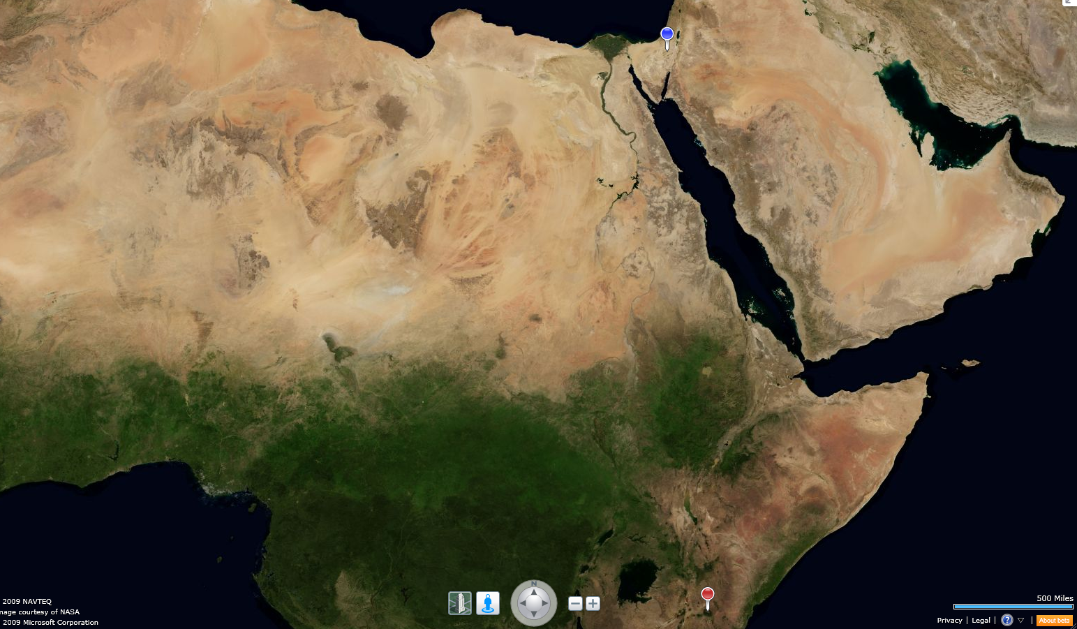
Below, in this gorgeous satellite mosaic of a cloudless Africa and Middle East, we see the telltale markings of the Great African Rift Valley, running from Mt. Kilimanjaro (red marker), due north through Israel (blue marker), forming the Jordan Rift Valley, Dead Sea, Jordan River Valley, and the Beqa'a Valley in Syria.

While here take some time to enjoy the breath taking image of Lake Victoria, the Nile River and Delta (the verdant delta of the river being seen here quite literally). This is the first time I have ever seen evidence of the boundary between Israel and Egypt on a satellite image. If you look closely at the Negev's boundary with Egypt, you can see the triangular shape of the Negev's border clearly delineated on the map. I have no idea what causes this feature.


Great African Rift Valley, Lake Victoria, Nile River and Delta, Jordan Rift Valley, Dead Sea, & Jordan River Valley

Cloudless satellite images of such extent are difficult to prepare. They consist of thousands of tiled mosaic images of an area, each one taken when no clouds were present. This is the way the earth usually looks from space:

The cloudy third planet from the Sun

Large scale cloudless satellite mosaics were pioneered by Tom van Sant in the late '80s, and his satellite mosaic maps of a cloudless earth are some of the best known. I once had the privilege of interviewing Tom van Sant when he was a guest lecturer at the University of California, Berkeley, and I was the project manager for Project Sequoia 2000.


 Tom van Sant's original cloudless Earth, from thousands of satellite mosaic images


Wednesday, November 18, 2009

Where is Mitzpe Ramon?

Many people draw a blank when we tell them we are moving to Mitzpe Ramon. It is a small and remote town in Israel's High Desert, so perhaps this is not surprising, unless you have visited it to explore Ramon's Crater or stopeed on your way to Eilat down Route 40. But Mitzpe Ramon is one of the easiest places to visualize: it sits right in the geographic center of the triangle of land that comprises Israel's Negev, the Desert.

"A" marks the spot:


Ramon's Crater itself occupies a remarkably large swath of the Negev with Mitzpe Ramon located at the center of the northern rim. There is only one road, Route 40, that cuts through the center of the crater, linking Eilat to the south with the rest of Israel.


Here is a larger topographic view that gives a better idea of the crater terrain and the wadis and nachlot that run through it.


Here is a topological view from an altitude of 23 miles. The airport indicated by the symbol was proposed but never built in Mitzpe Ramon; however, there are Israeli air force bases nearby.


Finally, this close-in topological street view gives some idea of the town's relationship to the crater, showing just how close the town lies to the crater rim. We live in the old section of town, hard by the crater's rim.


Related Posts with Thumbnails